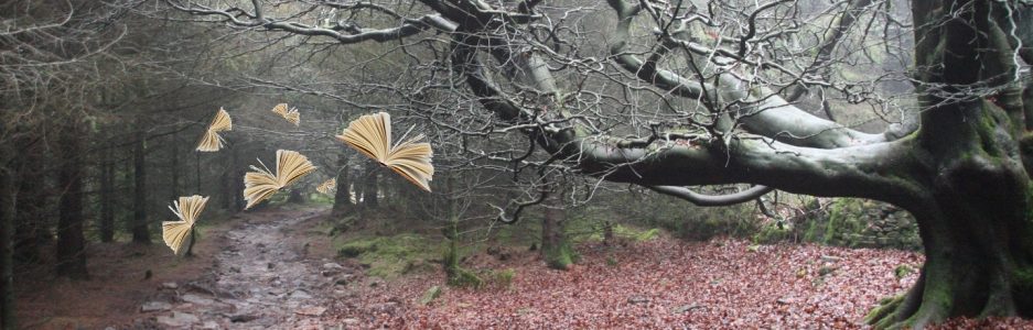

The wonky ring
The Tolkien Trail is a mythical path. It is a circular trail that, strictly speaking, is neither a trail nor circular, but a sequence of footpaths fictionally soldered into an unending worm that starts where it finishes and vice versa. It begins at Stonyhurst in the land of the Shireburn baronets
It is unlikely, though not impossible, that the author of The Hobbit, and The Lord of the Rings ever walked the trail as a single exploit. It is very likely that he trod sections of it. He stayed at Stonyhurst on more than one occasion whilst visiting his sons, one who was training to be a priest, and another who was a teacher there.
There are suggestions that The Shire, the fictional home of the Hobbits, was inspired by the countryside of the Ribble Valley. This is possible too, but perhaps no more so than other English rural retreats, including Worcestershire, where the author spent much of his childhood.
The trail
What follows is an augmented guide to the walk.
The main directions (bullet points over a green background) are lifted from The Tolkien Trail website.
I’ve added some Hobbit-sized detail in between.
2025 update:
Since compiling this post, several improvements have been made by the Stonyhurst Estate. The track is now easier to follow. Signage has been improved, as has the ground underfoot in places. You should still be sure to wear sensible footwear and take a guide or map.
The section at Winckley Hall Farm is now diverted around the farm rather than through it. This means that the trail no longer goes directly past the ancient tree pictured above, though it can still be viewed from the gate at the point where the diversion returns to the river Hodder.
Is it far?
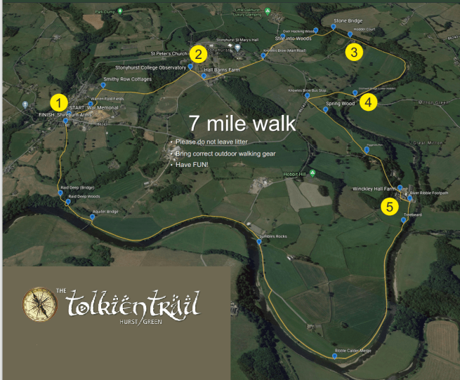
The trail is described variously as 9km (5.6 miles) or 10.8km (6.7 miles) . My own pedometer clocked 11.15km (very nearly 7 miles). It took three hours, not including a couple of breaks.
It is possible to shorten the walk by slicing off sections. You can work out short cuts from the aerial view above, and from maps. I’ll point out a couple in the description below.
There is some rise and fall in the topography, but nothing too testing and the majority of the walk is relatively level.
You will need:
- Very sensible footwear (Boots or robust country walking shoes.) Parts of the walk can be very muddy even when the weather is dry.
- A route guide.
You may also benefit from:
- Weatherproof clothing
- An ordnance survey map (OS Explorer Map 287 covers the whole walk area)
- Refreshments.
Part one: the fellowship is the thing
“As for where I am going, I have no clear idea myself, yet,” said Frodo.
(from The Fellowship of the Ring)
Finding the start is one of the trickiest tasks as the trial is not signed, though some of the paths are.
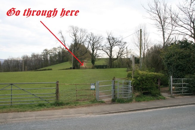
First get to Hurst Green. It is situated on the northern side of the gorgeous Ribble Valley between Preston and Clitheroe. The postcode BB7 9QJ will get you to the village.
When you arrive at a triangular junction in front of the Tolkienesquely resonant Shireburn Arms, you are there. The village can get busy at popular times. Some parking is available for a modest cash donation at the Memorial Hall on Avenue Road (BB7 9QB).
There is a public convenience in the centre of the village, very close to the start of the trail.
The initial section of the trail crosses the core of the Stonyhurst estate which is the historic legacy of the Shireburn family and dates back to the 13th century. In 1794 the family donated it to the Jesuit order and it has remained a place of Catholic education from that time onwards.
The historic fellows of the college comprise a number of notable persons, including one of the founders of the United States and the creator of Sherlock Holmes. Yes, Conan Doyle had his elementary education here.
By walking the trail, you join another fellowship: the appreciators of the splicing of nature and literature.
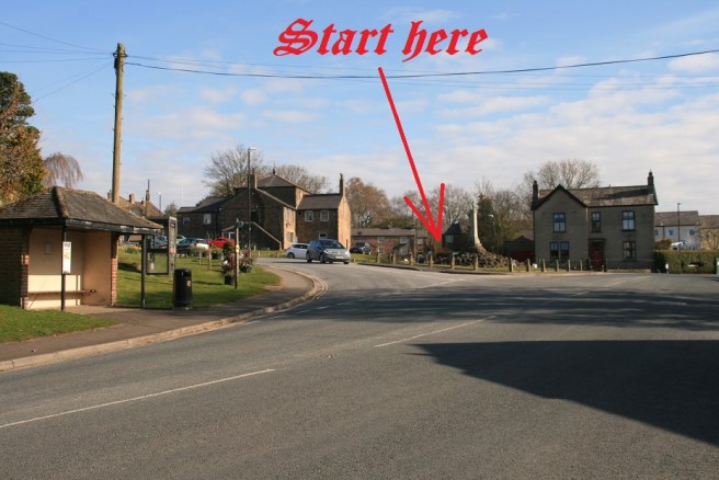
- Start at the WAR MEMORIAL in the centre of Hurst Green (opposite Millie’s Cafe). You will see the sign WARREN FOLD opposite the Memorial – walk along this road towards SMITHY ROW COTTAGES then bear right. Follow the path [800 METRES] towards Stonyhurst School keeping FOX FALL WOOD on your left.

The first part of the walk currently skirts a new estate. When Warren Fold ends, go over the stile and follow the left-hand wall for a few yards to the gate into a large field. You may be able to see what appears to be a house in a field on your right, away to the east. This is actually the college cricket pavilion. Head roughly towards it through the field you are in and the next one, keeping all the time to the field boundaries on your left.
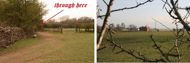
When you get close to the pavilion, follow the left field boundary around Fox Fall Wood and aim for a gate close to the dome of the college observatory.
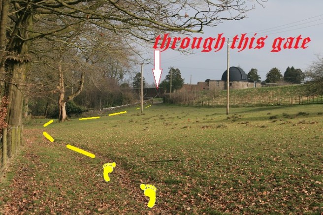
- STONYHURST CATHOLIC SCHOOL [20 mins from start]: After FOX FALL WOOD go through a wooden gate and turn right towards Stonyhurst School OBSERVATORY. Continue along this track [150 METRES] until you reach HALL BARNS FARM. Turn left and walk [600 METRES] towards KNOWLE BROW.
- Cross the main road and immediately opposite/left follow the farm track [350 METRES] until you reach OVER HACKING WOOD. Now turn RIGHT into the field.
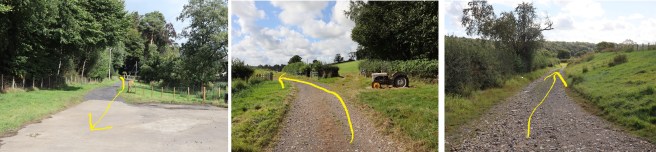
You leave the vehicle drive where it curves strongly to the left at one of the southerly tail ends of Over Hacking Wood. There is a public footpath sign. You go right here, keeping the wood on your left until the tree line starts to bend back on itself in a right-hand horseshoe, and the path enters the wood. (The stile mentioned in the official guide excerpt below has disappeared, (April 2021) but the path is obvious.) (Update Spring 2023: this part of the path has been improved and is now fenced and clear.)
- Keeping the woods on your left walk [350 METRES] until you reach a gate/stile. Go into the woods.
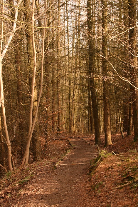
Enter the wood and you will see a definite footpath leading through a very Middle Earth ambience and descending 127 woodland steps towards the smell of wild garlic (possibly) and the sound of flowing water (definitely). This is the River Hodder, one of rural England’s least known delights.
- Follow the path [250 METRES] down to the STONE BRIDGE.
- Cross the stone bridge and walk up the hill [200 METRES] towards HODDER COURT.
The bridge is not over the Hodder, but over the tributary brook on your right. The hill is the most strenuous climb so far, but if things go badly wrong there is a defibrillator at the top. At this point you are about one third of the way along the walk.
Part two: the two rivers (twice)
“Riders!” cried Aragorn, springing to his feet. “Many riders on swift steeds are coming towards us!”
(from The Two Towers)
- HODDER COURT [1 hour from start]: Continue past Hodder Court and walk [150 METRES] down towards the RIVER HODDER. Go through gate into field and follow path [1000 METRES] until you reach the main road.
Hodder Court is where Arthur Conan Doyle spent some of his time at Stonyhurst. Theories have been expressed that the Ribble Valley fogs and the environs of Stonyhurst inspired The Hound of the Baskervilles Sherlock Holmes story. Residents of Dartmoor might disagree.
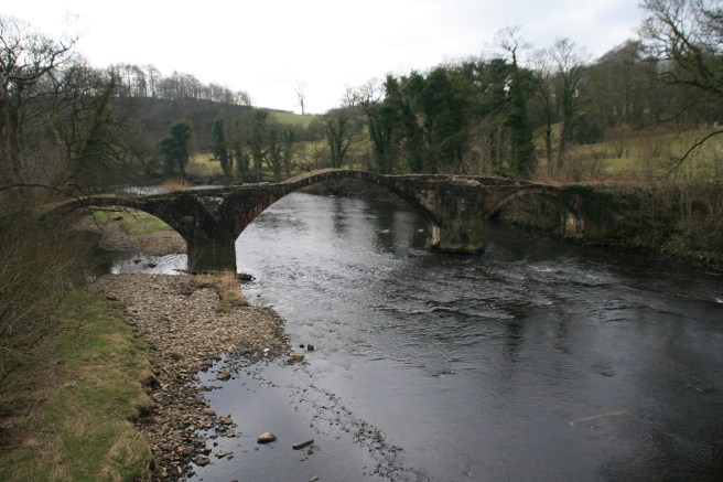
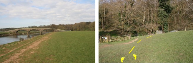
When you reach the road at Lower Hodder Bridge (no 4 on the aerial view above), you will see the ruin of an earlier bridge known as Cromwell’s Bridge fifty yards downstream. While historians are confident that Oliver Cromwell visited Stonyhurst on his way to the Battle of Preston in August 1648, there are doubts that he used this particular bridge.
- CROMWELL BRIDGE [1 hour 15 mins from start]: Turn RIGHT at Longridge Road and walk [420 METRES] up to KNOWLES BROW bus stop.
This is the only section of the trail that uses the main road. There is a good footpath for the majority of this short stretch, but it is narrow, so be vigilant for the threats of demonic horsepower. Knowle Brow bus stop is obvious: it is a shelter in the centre of a triangular junction.
Short cut 1:
By eliminating the River Ribble section (below) and walking back to Hurst Green from Cromwell’s Bridge westwards along the B6243 Road you can reduce the total length to about 8km or 5 miles, but you also eliminate some delightful vistas in favour of keeping a keen eye out for traffic.
OR
Short cut 2:
You can follow the road uphill from behind the bus stop and that will take you back to Knowles Brow (main road) (Between 2 & 3 on the aerial view above) where you can turn left and retrace your steps back to the start. The length of each of these alternatives is roughly the same.
To remain on the trail:
- Go through the gate opposite the bus stop and walk [200 METRES] towards SPRING WOOD.
- Keeping the woods on your left walk another [450 METRES] towards PIGGERIES PEN and go through gate.
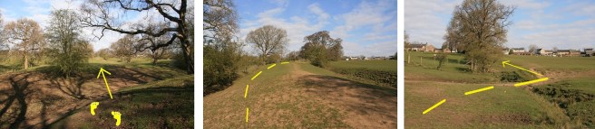
When I first walked the trail, the path between the bus stop and the Piggeries was not obvious, but since then many more feet have pounded the ground and it is now much clearer. Keep Spring Wood on your left until an impressive new hardcore path cuts across to the right-hand side of the field via a kissing gate in a fence. When you reach the tarmac road . . .
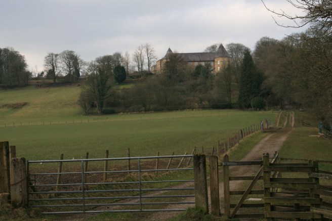
- Turn LEFT and walk [500 METRES] down the private road to WINCKLEY HALL FARM – walk through the farm to the River Ribble footpath.
Don’t be afraid, but do be respectful, as you walk directly through the farm. Walk straight towards the farmhouse then turn left and keep following that track. Dogs and unruly children on leads please. There may be livestock close by.
The section at Winckley Hall Farm is now diverted around the farm rather than through it.

You are now just over half way through the walk. You are also now on the Ribble Way.
- RIVER RIBBLE FOOTPATH [1 hour 40 mins from start]: Follow river footpath [2000 METRES] to JUMBLES ROCKS (WEIR).
The latter half of the walk is very easy to follow, with a slight ambiguity when you leave the river – but I’ll clarify that. Just keep the river immediately on your left and for the most of the way the path is obvious.
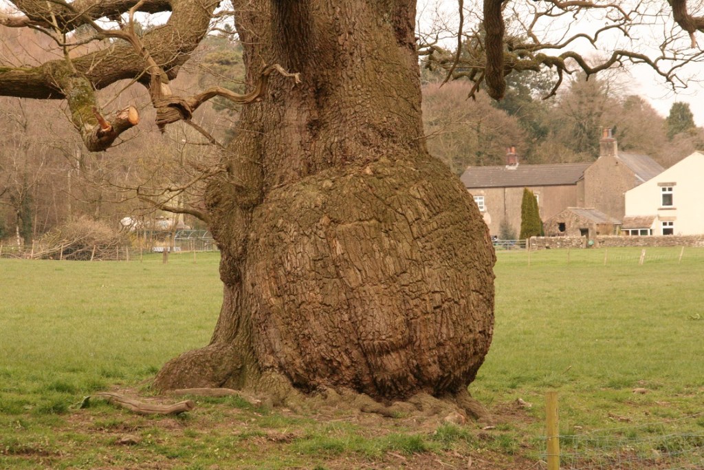
Tolkien and nature lovers might appreciate a very old, and very portly, Ent-like tree as you leave the farm and approach the river Hodder again.
Thirty yards after that, the Hodder loses its identity and flows into the Ribble at the first of two confluences that you will witness.
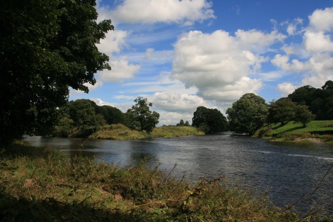
Go with the flow, literally, and after about a quarter of an hour you will be opposite the Jacobean mansion, Hacking Hall, and at the second, and smaller, confluence where the river Calder concludes.
You are now about two thirds of the way along the trail.
Part three: the return to the Shire(burn)
They passed through the West-gate and on towards the Shire.
(from The Return of the King)
The path diverts slightly from the river bank at a small building at Jumbles Rock weir, which is actually a flow measurement station. Keeping going with the flow, westwards, firstly along a tarmac track and then back on the riverside path. Stick close to the river.
- From JUMBLES ROCKS (WEIR) continue along path [1500 METRES] to RAID DEEP WOODS.
You will see an impressive bridge over the Ribble. This is actually a 19th century aqueduct that used to take water from Whitewell to Blackburn via an underground pipeline. You will clearly see the pipes on the structure. The path skirts around the fenced edge of the aqueduct. The stile there has all but disappeared, but there’s a gap in the fence. Carry on until you are confronted by woodland.
This is another place where the walk used to be a tad confusing, which is the last thing you want with only a kilometre to go. Here also, many feet have made the way clearer. Take the right hand of the two gates, and follow the well-trodden path over footbridges. With the river directly behind, you must now head uphill.
- Walk through gate into woods and follow path [100 METRES] to the small wooden bridge. Finally walk up the field [600 METRES] towards Hurst Green and finish at The Shireburn Arms car park.
When you emerge out of the woods the path can vanish on the slope ahead, but keep calm. Walk straight up between the field fence on your left and a brook in a gully on your right, until you see a small bridge over the gully which you cross. Then, keep close to the new left-hand hedge and it will lead you directly to a stone stile into the car park of the Shireburn Arms.
Walk to the front of the pub, or maybe into the cosy interior that would surely have been familiar to the pipe-smoking creator of Hobbits.
“Well, I’m back,” he said.
(from The Return of the King)
You can, of course, do the entire trail widdershins (counter-clockwise). It’s the same length.
Another shorter version
You can shorten the walk to 5.5miles (8.2km) (2hrs 10mins) by excluding the Hodder River section. When you reach Knowles Brow, instead of crossing the road, turn right onto it and follow it downhill to Knowles Brow bus stop. Then continue to follow the directions from there. The downside to making this cut is that you lose what is arguably the part of the walk that is most evocative of the Shire in Middle Earth.
2022 Update
The penultimate part of the walk along the Ribble north bank leading to the aqueduct has been newly fenced and partly protected with what appears to be strips of artificial all-weather sports turf. This makes the track unmissable, if slightly less familiar to Hobbit feet.
Influenced
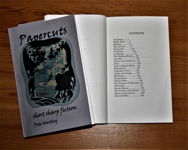
Tolkien, Conan Doyle and several other alumni of Stonyhurst, are depicted in Elementary, one of the short stories imprinted in the Papercuts paperback.
The notion that Sherlock Holmes might have solved a crime in Lancashire influenced a play:


2 thoughts on “Trailing Tolkien”