
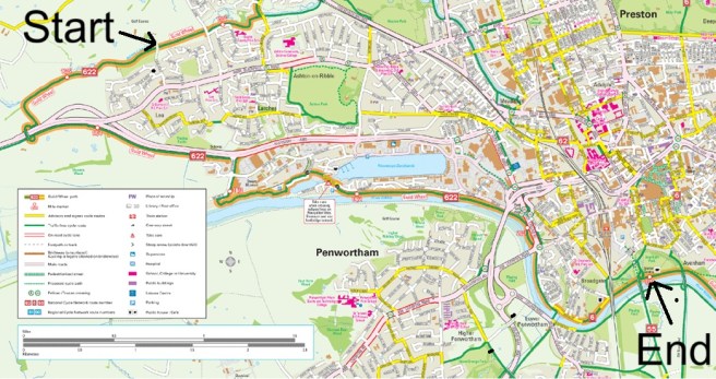
The Guild Wheel is a 21-mile circular route around the northern outskirts of Preston in Lancashire and slicing through the picturesque centre of the city via Avenham Park. It is a shared space for cyclists and pedestrians.
The route is mainly off-road apart from a few minor roads and even fewer main road crossing points. It is a suitable cycling and walking route for all the family. It is mainly reasonably level with some inclines, but nothing prolonged or significantly steep except for a section in the Brockholes Wildlife Reserve, which is the one place I felt would not be suitable for mobility scooters. Another steep section near Bluebell Way has an alternative by-pass.
All travel and refreshment information is correct as of November 2025, but subject to change, so please check before setting out.
The route which was created to mark the 2012 Preston Guild celebration is well signposted. (If you are puzzled by the term Preston Guild, see my earlier post: One Giant Leap for Childkind)
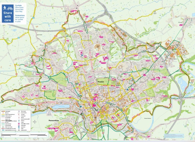
You can download this map from Lancashire County Council: guild-wheel.pdf
My wife and I decided we would like to complete this long-distance path in four sections. We drive, but decided that we would conduct the walk using only public transport to avoid having to double back to recover the car. So, here is how you can do it using Preston Bus Station as the hub for each expedition.
You can start and finish anywhere on the path. We decided to begin at the official start point. You can, of course, walk it in either direction and log your progress using the mileposts which are numbered for each way. We decided to go anticlockwise, for the simple reason that the final part was the most familiar and we were keen to explore the parts we didn’t know.
This guide is split into four sections: three of five miles and the initial stretch of six.
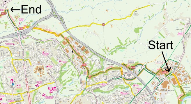
Section one: Avenham Park to Red Scar
Distance: 6 Miles.
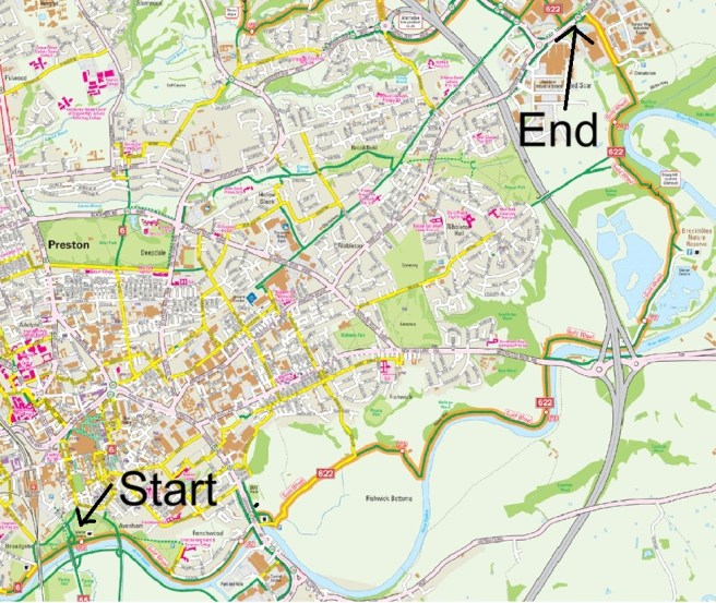
Start: The Visitor Centre Pavillion Café
There are no buses directly to the start point but there are some that skirt the edges of the park. You can get Preston Bus No 112 to Ashworth Grove which will drop you directly on the Guild Wheel at the one-mile post. You could therefore make that your start and reduce this section to five miles.
Alternatively, you could catch a bus (there are several) to Preston Railway station. There is a newly opened path directly from the station passing the car parks and leading to the Guild Wheel close to the official start point of the Pavillion. (Adds an extra half mile to this section.)
End: Longridge Road, at the access to Preston crematorium.
Return to Preston Bus Station from Longridge Road using the No 1 service from Longridge. The bus stop is at the entrance to the crematorium.
The route
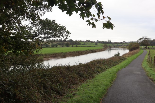
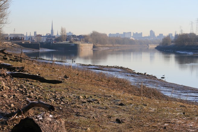
Set off eastwards (upstream) along the riverside path from the Pavillion Café. You will join The Boulevard at Frenchwood, passing the one-mile post at Ashworth Grove and then arriving at the A6 London Road. Cross this very busy road as directed by the blue and white Guild Wheel signs to take the footpath alongside the former garage (now car wash) which leads you to a delightful road servicing the few properties and farms to be found along Watery Lane. Here you are permitted to follow a private road before being diverted onto a path and passing the two-mile marker. This track hugs the riverbank for a while before wending through Melling Wood and passing the three-mile post to approach the A59 at Brockholes Brow. The drone of the M6 will give you advance warning.
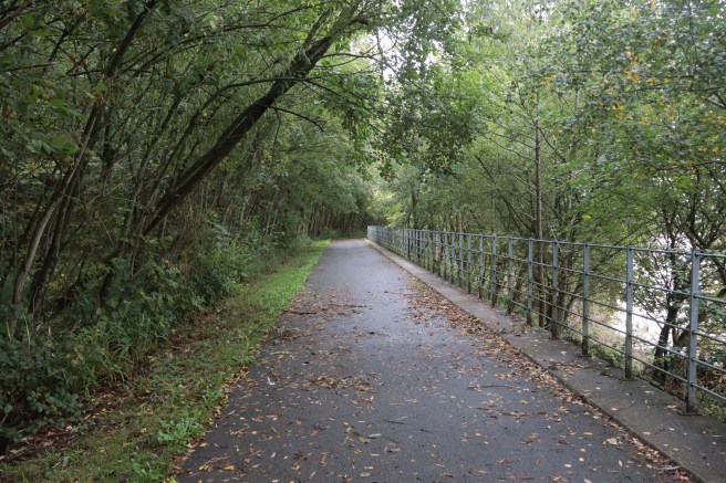
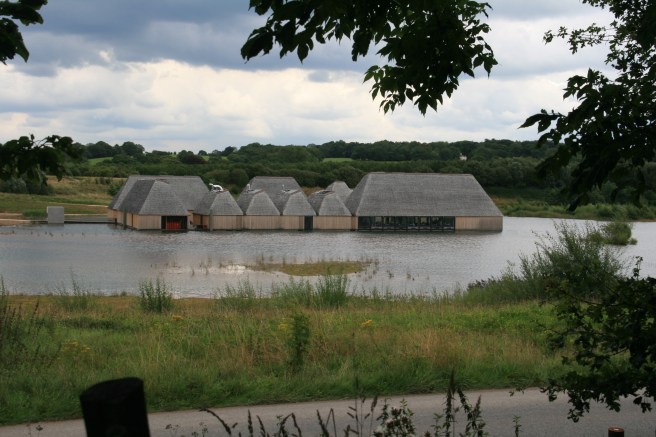
The path takes you comfortably under the busy A59 where it bridges the Ribble. (The M6 crosses the Ribble away to your right.) The Guild Wheel then joins the charmingly named Loverose Way which leads you directly into the entrance to Brockholes Nature Reserve. As you align with the foot of the lake you will be directed to switch sides of the drive. This is the four-mile point. After another third of a mile or so, you can take a short diversion to visit the refreshment and comfort facilities at the visitor centre. (NB the café is only open on certain days, but toilets are open each day and very basic refreshments can usually be found in the shop.)
You can slightly extend your walk by taking the reserve tracks that hug the river but be sure to rejoin the Wheel as indicated on the map. The ascent from Brockholes is the trickiest section of the whole circuit depending on your mobility. As country walks go it is not especially difficult but those relying on motorised mobility aids may find it a barrier, which is a shame.
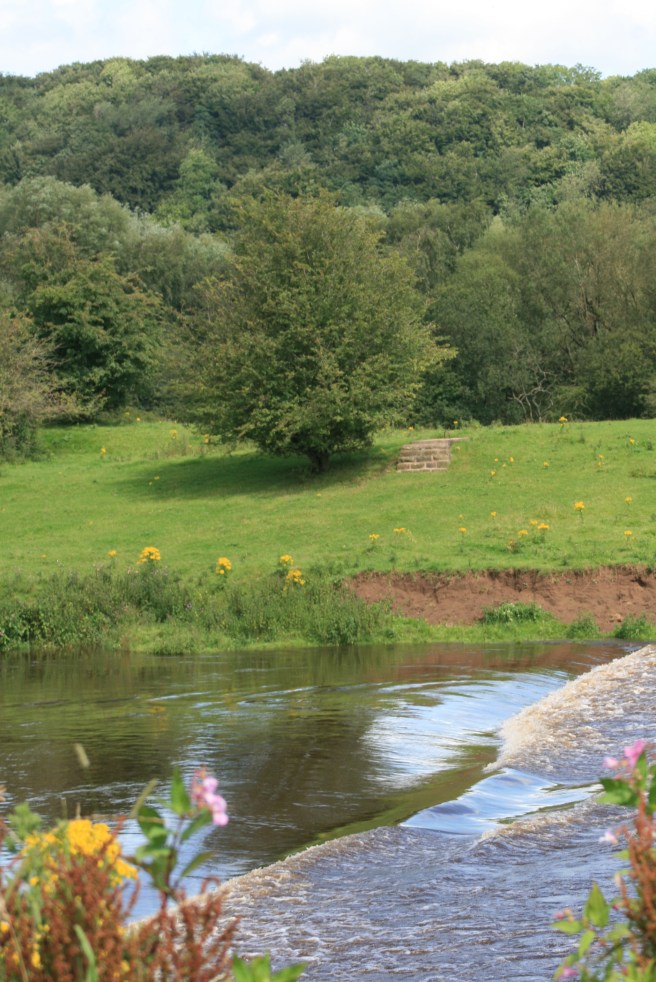
After looping around half of the Ribble’s horseshoe bend, the path takes a left-hand turn to lead you directly to the access road to the crematorium, which you follow to its origin on Longridge Road between the Red Scar and Roman Way estates. You are just a few hundred yards shy of the six-mile marker.
Historical Note
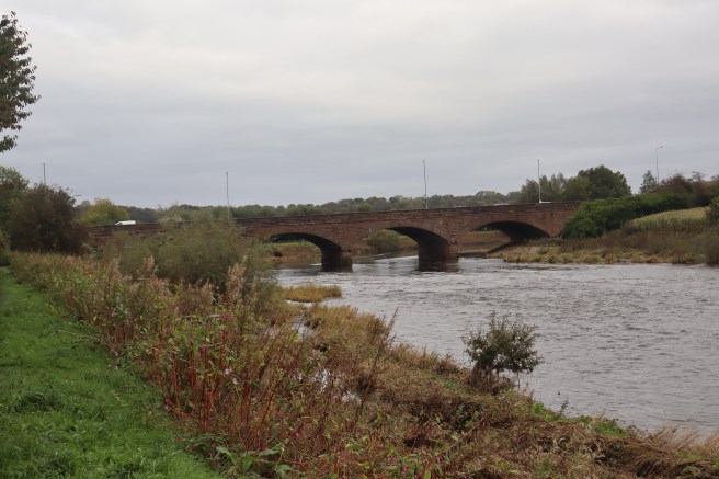
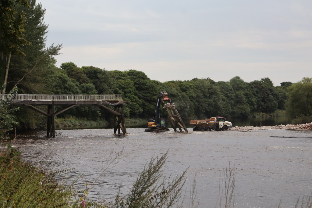
There are nine bridges over the River Ribble where it skirts the city of Preston. You will pass all of them on this walk, crossing none, but walking under four. Three of the bridges were built for railways, only one of which is still in use for that purpose. The first you will pass is the new pedestrian and cycle bridge currently being constructed to replace the Old Tram Bridge. As you cross the A6 at London Road you will see the oldest river crossing point near Preston. The current structure was built in 1781 replacing a bridge built in 1625. There are records of one as long ago as 1302, and it is thought that the Romans may have been the first to construct a bridge here.

The Walton bridge was contested during the 1648 Battle of Preston during the Civil War. The action was mostly north of Preston, but at one point saw Parliamentarians making their way along a boggy track called Watery Lane to reach the bridge via a marsh known as Fishwick Bottoms.[1] The bridge was subsequently taken by Parliamentary pikemen pushing from the north – your perspective during this walk.
The Roman camp at Walton-le-Dale over the bridge is thought to have been a supply base; a kind of first-century fulfilment centre serving the forts at Kirkham to the west, Lancaster to the north and Bremetennacum (Ribchester) to the east.
Ribchester, eight miles away by road or six as the heron flies upstream is the next bridging point over the river today.
Red Scar was the site of the world’s largest rayon factory when the Courtauld company set up their works in the late 1930s. As Preston’s traditional trade of cotton weaving went into decline Courtaulds partially prolonged the craft with synthetic fibre, providing employment for a large number of townsfolk, including many recently arrived migrant workers. At its peak it employed nearly four thousand people. Its closure in 1979 hit the town hard. In my youth, its massive cooling towers were a significant homecoming landmark.
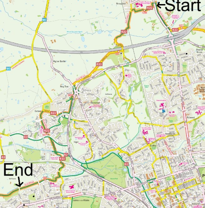
Section Two: Red Scar to Broughton
Distance: 5 Miles.
Start: Longridge Road, opposite Preston crematorium
Catch the Stagecoach No 1 service to Longridge alighting at Roman Way.
End: Garstang Road in Broughton village.
Return to Preston Bus Station from Garstang Road using one of the several Preston Bus or Stagecoach services that head south along the A6. We used PB No 45.
The route
This section is a little twisty but just keep following the blue and white Guild Way signs, which are plentiful and sometimes augmented by the monogram GW painted on the path itself. Walk down Roman Way past the recycling depot.
At the end of Roman Way go straight on along the track ahead until it ends at the six-mile point. Turn left (or right to follow an alternative foot-only diversion) and walk along what was once the Preston to Longridge railway line. This leads you to the B6242 on its approach to the roundabout forming the southbound-only entrance at Junction 31A of the M6. Turn right to walk towards that roundabout. This is one of the busiest stretches of the Guild Wheel with respect to road traffic, but you are able to keep to footpaths and cross the roads at safe points. (The walking diversion rejoins the cycleway at this roundabout.) The Guild Wheel continues adjacent to the M6 slip road, and once more you are free of four-wheeled monsters.
Alternatively, walk along Bluebell way to avoid the steeper sections of the cycle path. The slopes that you will avoid are not as significant as the one at Brockholes and have a better surface finish.
On the main route, you will pass the seven-mile marker just before a jack-knife turn onto Fulwood Row. You are now one-third of the way around the Guild Wheel from the official start point. Shortly after passing under the motorway turn right onto a track known as North Highfield. Keep on this very pleasant path, crossing Fernyhalgh Lane and reaching Midgery Lane just after the eight-mile marker. Turn right and walk along Midgery Lane. When you reach Loxley Green the road stops, but you carry straight on towards Pitman Way, which you cross and continue in the same direction.
The stretch that you are now on runs between the various businesses of Pitman Way and Eastway giving you options for refreshment and comfort breaks. The Asda store is just before you cross Pitman Way. It has a McDonalds café, and toilets. If you continue for a further half mile you’ll reach Oliver’s Place where, if you take a short diversion towards the roundabout, you will find Subway, Gregs and Aldi.
Back on the track midway between Oliver’s Place and D’Urton Lane you will pass the nine-mile marker, then at the end of Midgery Lane turn left onto D’Urton Lane which you will follow all the way to the busy James Towers Way (not depicted on the map above) and the M6 Junction 32. Ten miles are now done in total. Cross at the pedestrian crossing and follow the Guild Way signs along the A6 to reach the village of Broughton. You are just over halfway around the Wheel from the official start.
The Toll Bar Café, when open, is very popular, which is always an indicator of quality cuisine.
Historical Note
The Battle of Preston, mentioned above, was fought on the moor to the northeast of the town. Cromwell approached from this direction having spent the night at Stonyhurst. The battle was conducted among the fields in the area you walk through during this section. There are memorial sculptures overlooking the roundabout on Bluebell Way. You won’t see these from the main path but can catch sight of a set of carved heads staring at unsuspecting drivers if you take the Bluebell Way diversion.
The Preston to Longridge railway was a six-and-a-half-mile branch line that opened in 1840 and was operated initially by horses. It transported stone from the Longridge quarries, as well as other goods and passengers. It was eventually attached to the main line via a tunnel by 1885. It ceased operating in 1968.
As you pass under the M6 at Bluebell Way and again approaching James Towers Way you are walking under the UK’s first stretch of motorway opened in 1958 as the Preston bypass. It took traffic from the A6 at Bamber Bridge, returning it to the same road at Broughton. Even when the motorway was extended to the north, the village remained a notorious bottleneck until the James Towers way opened in October 2017.
James Towers was a Broughton resident awarded the Victoria Cross during the First World War for rescuing a party of thirty men who had failed to receive the order to withdraw ahead of a German advance in 1918. The five individuals who had attempted the rescue before him, had all been killed. He survived the war and returned to his parents’ farm near Broughton. He died in 1977.
Section Three: Broughton to Lea
Distance: 5 Miles.
Start: Garstang Road in Broughton village
There are various services that stop in Broughton including the Stagecoach Nos 40. 41, 940 & 941; and Preston Bus 45, 433 and 437.
End: Tudor Avenue, Lea
Return to Preston Bus Station using Preston Bus No 31.
The route
Step straight off the bus and onto the Guild Wheel, unless you wish to first grab a coffee at the Toll Bar Café over the road. (Check opening times.) The blue and white GW signs are right alongside the bus stop setting you off on your westerly swing across northern Preston.
The easy-to follow, easy to walk, track takes you to Nog Tow via parts of Lightfoot Lane. You’ll pass the eleven-mile point around the rear of Broughton Enterprise College and hit twelve miles after Lightfoot Green Lane loops you over the M55 motorway. Here you turn right into Sandyforth Lane to pass the Preston Grasshoppers rugby fields.
Sandyforth Lane feeds into Lightfoot Lane which ends at Tabley Lane. This is the one place where my fellow walking-wheeler and I went wrong. We failed to see the signs directing us towards the roundabout and continued straight on to Hoyles Lane. Having checked, there appears to be a lack of clear signage at this junction if you are going anticlockwise around the Wheel, unless you keep your eyes to the ground and follow the GW initials painted there.
I feel this was a fortuitous error though, as we were easily able to connect back with the Wheel at Miller Green in Cottam and our route was much more peaceful than if we had followed the official one along Tom Benson way. If you follow the official route, turn right onto Tom Benson Way and right again at Merry Trees Lane, and at Miller Lane.
Whichever way you go you’ll pass the thirteen-mile point as you leave Nog Tow.
Picking up the pleasant footpath at the southwest corner of Miller Green you are now heading south. Continue along the ‘Valentines Lane’ path passing first the fourteen-mile post just before Cottam Way and then over the Lancaster Canal at the University of Lancashire (formerly Uclan) Sports Centre Final Whistle Café. (Mostly open on weekdays but check times.) As you leave the sports arena you are directed onto the Ribble Link canal path soon passing the fourteen-mile (two-thirds of total circuit distance) post.
We continued to Tudor Avenue, but you could terminate this section at the bus turning circle on Savick Way which is bang on the GW path, shortening this slice by perhaps a third of a mile. A little further takes you across Lea Road where, at the fifteen-mile point, another bus-hopping opportunity awaits. We chose Tudor Avenue because it seemed to fit best with our plans, leaving just over five miles remaining for our final stretch. The Ashton and Lea Golf club café at this junction welcomes non-members when open.
Historical Note
Both this section and the previous one take you through parts of the town that have been significantly developed over the last half century. The north edge of the city has been extensively developed for retail and light industry as well as for housing. The Guild Wheel is predominantly still pleasantly rural in feel for much of its circumference, however.
The Ribble Link is a canalisation of a stretch of the Savick Brook which opened for navigation in 2002. It meant that, for the first time, the Lancaster canal was connected to the wider canal network via the River Ribble and River Douglas. Boats can now also navigate to and from the marina in Preston Docks. Navigation is only possible at certain times of the year.
Section Four: Lea to Avenham Park
Distance: 5 Miles.
Start: Tudor Avenue, Lea
Catch the Preston Bus No 31, 19A or 48 or Stagecoach 61 or 68 alighting at the Pig and Whistle pub on Blackpool Road. Alternatively, stay on board the PB services to alight at the same stop you used to return from Tudor Avenue.
End: The Visitor Centre Pavillion Café
The route
Cross Blackpool Road and walk down Tudor Avenue to pick up the Guild Wheel at the entrance to the Golf Club. Turn left onto the Guild Wheel and simply follow this pleasant canal-side path until you pass under the new Edith Rigby Way road (not depicted on the map above) just after the sixteen-mile post. You are then guided up and over the A583 Blackpool Road at the pedestrian bridge. You are now at the extreme west point of the Guild Wheel.
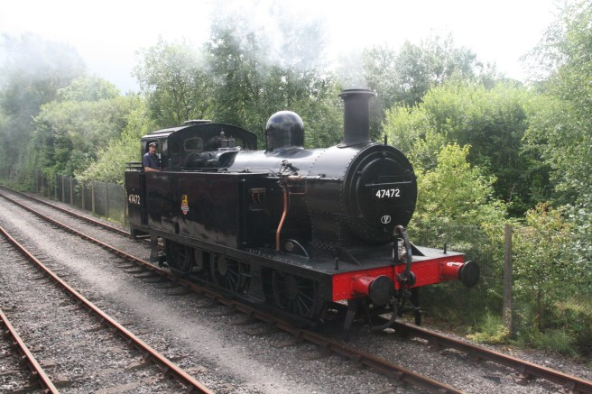
What follows is the least pleasant part of the circuit as you walk eastwards for just over a mile passing the seventeen-mile marker and almost reaching the eighteen-mile post in the company of the noisy A583. Relief comes as you turn right towards the river at Nelson Way. Here you pick up a much more peaceful path that loops you around the back of the Booths distribution depot and the Ribble Steam Railway. This is an easy and interesting stretch where you get views of the river and the Preston Dock basins.
An excellent place to take a break is just before the swing bridge between the dock basins where you will find the popular and nearly-always open Beach Hut Café. After crossing the bridge, the path follows the heritage rail line along a lovely stretch of the Ribble between the nineteenth and twentieth mile posts. You pass under the A59, flyover; the fifth in our collection of Ribble Bridges. The junction of the old A59 Liverpool and A5072 Stand roads is very busy but has been extensively renovated in recent years and traffic control makes crossing safe and easy. The old A59 bridge is the sixth on our collection.
The path now follows the river along Broadgate. Flood defences have been upgraded here and, at the time of writing, some of the work is still in progress so you may get diverted slightly through the adjoining streets. Our seventh bridge is the oldest of the three Penwortham bridges, now restricted to pedestrians and cycles, where the Wheel continues to follow the north bank along Broadgate.
As you enter Miller Park at the Continental Pub you pass under our eighth bridge carrying the West Coast main line trains into Preston Station and commence the beautiful final home straight of our circuit. Consider the glorious Victorian arch of the ninth bridge, that of a long disused railway track, as your finishing line because just a few yards beyond that is the Pavillion Café. Twenty-one miles completed.
Historical Note
Edith Rigby (née Rayner) (1872 – 1950) was an English suffragette who used arson as a way to further the cause of women’s suffrage. She founded a night school in Preston aimed at educating women and girls. Later she became a prominent activist and was imprisoned seven times. She was a contemporary of Christabel and Sylvia Pankhurst. Rigby lived in Winckley Square close to the start of this walk.
The Ribble Steam Railway uses a track that once served the docks. It opened in 2007 when stock and staff from Steamport in Southport decided to relocate. Trains currently operate on selected dates, mostly summer weekends.
The Port of Preston was once a vibrant dock. Its commercial operation lasted for nearly a century from the opening of the Albert Edward Dock in 1892, but it was always troublesome due to the nature of the Ribble, which had to be frequently dredged, and the fact that it could only accommodate vessels up to a certain magnitude and draught. When opened at a size of forty acres it was thought to be the largest freshwater dock in the world. The first set-back came with the Great War (1914-18) during which dredging was suspended, and it didn’t return to profit until 1921.[2] From that time onwards, however, a decline in the cotton trade had a significant impact. It was closed at times during World War Two due to naval mines and became a marshalling point ahead of the D-Day landings. In the late 1940s it pioneered the use of roll-on-roll-off ferries linking Preston with Northern Ireland. General trade through the port boomed in the 1960s but an emphasis on using larger vessels began a rapid decline resulting in the commercial closure of the docks in 1981. The splendid redevelopment in the final two decades of the millennium brought about the charming marina and its environs that you see today.
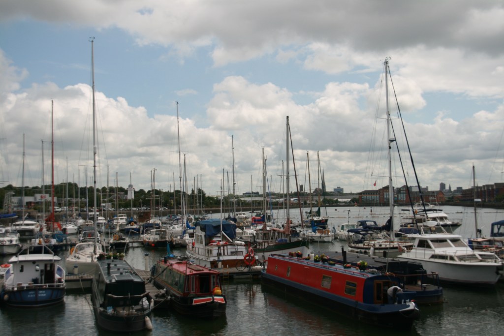
The excavation of the Albert Edward Dock threw up some of the most fascinating historic artefacts including bronze spearheads and human skulls dating as far back as 3820 BC.[3] Whether that person was a prehistoric Prestonian, or had, like you, travelled miles to be there, we will never know.
Notes and references
[1] See Battle of Preston (1648) – Wikipedia
[2] See Hunt D, The Wharncliffe Companion to Preston, Wharncliffe Books, 2007, page 107
[3] Ibid page 109
Influenced
A great deal of my creative work has been influenced by my home city. I wrote and staged a number of musicals and plays set in this area. See, for example Top Rank Groovy.
Several of my short stories are derived from places passed, or encircled by this walk including To Whom it may Concern and Gothic Revival in Christmas Present.
The play Making Myra premiered to sell-out audiences at the Continental pub. We had no notion that a copy of the script would end up among the personal effects of serial killer Ian Brady.
The Curator a short story in The Atheist’s Prayer Book is set partly in Avenham Park.
Roughly a quarter of Ice & Lemon is set in Preston.

Related posts
More on the River Ribble: The source of all Ribble
Another Lancashire walk: Trailing Tolkien
